Monday, March 24, 2014

Following Clues from Vietnam to Freeport, IL to Madison, WI - Harrison Forman Collection

The beauty of the Harrison Forman Collection is evident in his images taken from all over the world. What isn’t evident sometimes is the time, place or context of the images, which makes it difficult to describe them so users can find them online. Occasionally, our metadata creators refer to Forman’s notes, which may be incredibly detailed or sadly, very vague. In which case, they look for clues in the images themselves, hoping to cull as much information as possible to help users find relevant images for their research.

One such image of a man carrying a crate, as seen below, was simply labeled ‘Indo-China.’

fr302907
Our metadata creators were up to the challenge! Luckily, Forman wrote a diary while in Vietnam in November, 1950, so we were able to verify a time and place. The man was serving in Vietnam during the First Indochina War (1946 – 1954) on the French side. The context was a little more difficult, but a subtle clue was stamped right before our eyes. The label on the crate in the shape of a shield with the stars and stripes of the American flag says ‘From U.S.A. for Mutual Defense.’ Our research uncovered that the crate contained supplies from the United States through the Mutual Defense Assistance Act of 1949, legislation that provided non-military foreign aid to North Atlantic Treaty partners including France. The U.S. sent supplies to the French in Vietnam to support their fight against communism and the Viet Minh during the First Indochina War.

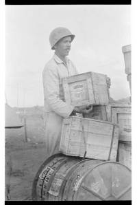
But the clues didn’t end there. We could just make out a stamp on the side of a crate that says ‘Burgess Battery Co. Freeport, IL.” A quick search uncovered that the Burgess Battery Co. was founded by Charles F. Burgess, founder of the University of Wisconsin – Madison Department of Chemical and Biological Engineering. Burgess also founded the Madison-based Rayovac Corporation (formerly French Battery Company), one of the country’s largest battery producers. Burgess developed flashlight and radio batteries in the early 1900s, with which, under military contract, he supplied the troops during World War I, suggesting that Burgess possibly continued military contracts in the future. Burgess left UW-Madison in 1913 and founded Burgess Battery Company in 1917, which he eventually moved from Madison to Freeport, Illinois in 1925 to start a new division.

Suddenly, an image of a man carrying a crate in Indochina became a much more complex story – one with Wisconsin ties!

To see the full record for the image, visit our Digital Collections Asia and Middle East portal

Sources:

Harry S. Truman: “Statement by the President Upon Issuing Order Providing for the Administration of the Mutual Defense Assistance Act.,” January 27, 1950. Online by Gerhard Peters and John T. Woolley, The American Presidency Project.

University of Wisconsin-Madison College of Engineering. (1996). ChE Funder also helped spur battery industry, Perspective, Vol. 23.

-Susan Dykes

Tuesday, March 18, 2014

Scanning Large Formats: 1861 Map of Korea

The UW Milwaukee Digital Collections hosts the American Geographical Society Library Digital Map Collection featuring nearly 2,000 maps. Everything from everyday local maps to historic treasures are included. One map, the Daedong yeojido or “Territorial Map of the Great East,” was added in 2009.

The map was part of a larger purchase by the American Geographical Society (AGS) of New York in 1895. Several maps, an atlas, and forty-three photographs were acquired from the father of American diplomat George C. Foulk. For more than one hundred years, the significance of those materials went largely unrecognized until 2008 when the map was recognized as a National Treasure in Korea.

1861 Map of Korea.
1861 Map of Korea
In preparation for a 2009 symposium, scanning the map became a priority. The map is a wood block print on twenty-two folded sheets which presented a new scanning challenge to staff. When displayed open, the map measures nearly thirteen feet wide and twenty feet in length. The long sheets were designed to be folded accordion style making this large map easier to use.

korea3
Map spread out in the AGS Library to the full 13x22 feet in size
 The map was scanned using a sheet feed Colortrak 4280 Color Scanner at a 300 dpi resolution. Images were saved as tiffs ranging in size from 24 MB to 95 MB with the composite image coming in at a walloping 213 MB.

Majority of maps are scanned using the sheet feed Colortrak 4280 Color Scanner.
Majority of maps are scanned using the sheet heed Colortrak 4280 Color Scanner


The composite image was plotted for the event using a 60 inch wide Hewlett Packard 5500ps plotter.
The composite image was plotted for the event using a 60" wide Hewlett Packard 5500ps plotter

The map is now available for viewing at the American Geographical Society Library Digital Map Collection where you can see details of each sheet, the manuscript index sheet and the composite view here.

More information about the symposium and the map can be found here.